Points of Interest - Bruchmühlbach-Miesau
Western Palatinate Moor Lowland – “In the Bog”
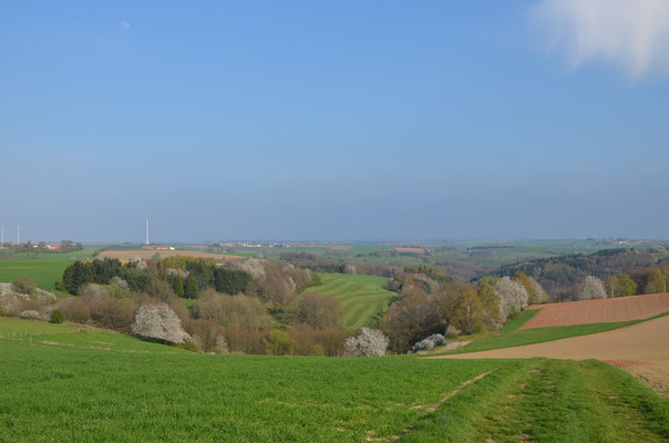
The Western Palatinate Moor stretches over the western Palatinate at a length of 38 kilometers. Up to the 1930s peat was cut there and used mainly as heating material. Today the landscape is shaped more by meadows and pastures with grazing cattle. The local fish farming goes back to the 12th century when Benedictine and Cistercian monks were the first to dam up springs and streams to breed fish, an important source of food at that time. With a width of 3 kilometers, Scheidelberger Woog was the largest of these fish ponds. Around 1770 it was drained and its peat extracted.
The section located in the Bruchmühlbach-Miesau Union Community is classified as a nature reserve and invites you for hiking and biking tours.


By loading the card, you accept Google's privacy policy.
Learn more
Westrich Plateau – “Up on the Heights”
Looking out northward from the heights on a clear day you have a wonderful view of the North Palatine Hills. Toward the west you see as far as the Saarland and in the south, you can make out Lorraine and Alsace. The Westrich Plateau is also called “Sickinger Höhe” (Sickingen Heights). It was named after the famous knight Franz von Sickingen whose castle ruin Nanstein perches above Landstuhl and is still worth a visit. Today the plateau consists mainly of pastures. But you can also find fields where wheat, barley, and potatoes are grown. Have you ever tasted potato schnapps? It is still distilled in Lambsborn.


By loading the card, you accept Google's privacy policy.
Learn more
Elendsklamm - Ravine
Access: along road L 464 from Bruchmühlbach to Lambsborn
Parking at “Bierkeller” parking lot and follow the signs B8 through the forest
Website: www.pfalz.de
Phone: +49 (6372) 922 01 06
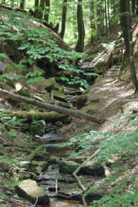
Located in the woods near Bruchmühlbach, the so-called Elendsklamm is a ravine with a length of 3 kilometers (1.9 miles). As it is unique from a historical and botanical point of view, the ravine is a very impressive natural landmark. You could also say it is a magical place. Since the responsible forestry commission office kept the landmark untouched, a primeval piece of woodland was formed in a way you rarely get to see it. The natural landmark enchants with its diverse geobotanical manifestations. Small step-shaped cascades and small bubbling waterfalls, sandstone rocks with bizarre forms of weathering, block fields, and overhanging layers of red sandstone are awaiting you. The Frohnbach Creek formed this unique landscape in the Mesozoic era. At today’s water level, it is hard to imagine that this creek had such impressive power. Ages ago, however, the Frohnbach was a roaring river. The “Tausendmühle” is located at the edge of the ravine. Built in 1598, it is the oldest historic corn mill in the region and got its name from the roaring river. In the course of history, the ravine repeatedly played an important role as a political and religious border.


By loading the video, you accept YouTube's privacy policy.
Learn more

By loading the card, you accept Google's privacy policy.
Learn more
Tausendmühle - Historic Corn Mill
Address: Tausendmühle 5, 66892 Bruchmühlbach-Miesau
Website: www.tausendmuehle.de
Phone: +49 (6372) 14 38
Surrounded by fields and meadows, the Tausendmühle is located in the outskirts of Bruchmühlbach at the foot of the Elendsklamm. The first mill on this site was built in 1598, therefore Tausendmühle is looking back on over 400 years of milling tradition. Until a few years ago, the mill was still in service. It was the only remaining functional corn mill in the Kaiserslautern region. Today the building houses a lovingly decorated mill store selling flour, cereals, muesli, organic food, and pet food. Mill machinery and equipment are displayed and a small museum in the former granary is in the process of planning. Furthermore, workshops in baking bread and making chocolates are offered.
Opening hours mill store:
Thursday and Friday 9.00 a.m. – 5.00 p.m.
Saturday 9.00 a.m. – 1.00 p.m.


By loading the card, you accept Google's privacy policy.
Learn more
Simultankriche - Historic Church
Address: Dorfstrasse 13, 66892 Bruchmühlbach-Miesau/ District Vogelbach
Website: www.tourismus-vgbm.de
Phone: +49 (6372) 922 01 06
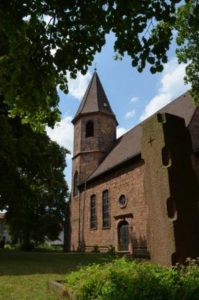
The structure was built in the 12th century. Originally it was a church with a pilgrims hostelry which was an important stopover for the pilgrims on the “Way of Saint James” to Santiago de Compostela in Spain. The church is a little younger than the Speyer Cathedral – today it is one of the oldest and most beautiful cultural monuments of the Palatinate. Besides late Romanesque components, the church combines Romanesque, Gothic, Baroque structure and modern style elements. The patron saints of the church are Saint Philippus and Saint James. Since 1672 the building has been a Simultankirche, which means it is used for services by both Protestants and Catholics. In 1986 it was added to the list of “protected cultural heritage” according to the Hague Convention.
Opening hours:
Visits on request – please contact the Ostermeyer Family (phone +49 (6372) 50 78 03


By loading the card, you accept Google's privacy policy.
Learn more
