
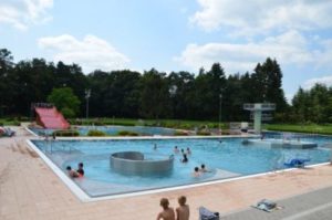
By loading the card, you accept Google's privacy policy.
Learn more
By loading the card, you accept Google's privacy policy.
Learn more

The map shown here is provided by tourenplaner-rheinland-pfalz.de. This is a third party provider. tourenplaner-rheinland-pfalz.de uses Outdooractive. By loading the map, you accept the privacy policy of Outdooractive.
Learn more about Outdooractive | Tourenplaner-rheinland-pfalz.de

By loading the video, you accept YouTube's privacy policy.
Learn more
The map shown here is provided by tourenplaner-rheinland-pfalz.de. This is a third party provider. tourenplaner-rheinland-pfalz.de uses Outdooractive. By loading the map, you accept the privacy policy of Outdooractive.
Learn more about Outdooractive | Tourenplaner-rheinland-pfalz.de
The map shown here is provided by tourenplaner-rheinland-pfalz.de. This is a third party provider. tourenplaner-rheinland-pfalz.de uses Outdooractive. By loading the map, you accept the privacy policy of Outdooractive.
Learn more about Outdooractive | Tourenplaner-rheinland-pfalz.de

The map shown here is provided by tourenplaner-rheinland-pfalz.de. This is a third party provider. tourenplaner-rheinland-pfalz.de uses Outdooractive. By loading the map, you accept the privacy policy of Outdooractive.
Learn more about Outdooractive | Tourenplaner-rheinland-pfalz.de